Hurricane Isaias strengthens into Category 3 storm ahead of landfall
Oct 09, 2026 | 11:35 am ET

Description
Lisa Quiggle of Foley, Alabama hands a sand bag to Samantha Riechers of Huntsville, Alabama at a sand bag site in Foley, Alabama as residents prepare for Hurricane Isaias on October 8, 2026. The hurricane strengthened to a Class 3 storm Friday morning and was expected to make landfall late Friday evening or early Saturday morning. (Dan Anderson for Alabama Reflector)
Hurricane Isaias strengthened into a Category 3 storm Friday morning hours before an expected landfall somewhere in the Florida panhandle.
The storm system had sustained winds of about 120 mph and was 245 miles south of Pensacola mid-Friday morning moving north at 15 mph. It is moving largely along the same track as before but shifted slightly east. Its path will continue north, with much of the storm expected to cover large portions of Alabama before moving on to Tennessee Saturday afternoon to evening.
“We will continue to really see the same impacts that we talked about, damaging winds, a few tornadoes possible in those bands, particularly across the eastern and southeastern portions of the state will have a better tornado risk, and heavy rainfall will continue as advertised between one and a half to four inches generally, with maybe some spots getting five inches of rain that could cause flooding in low-lying areas,” said Jason Holmes, a meteorologist with the National Weather Service based in Birmingham.
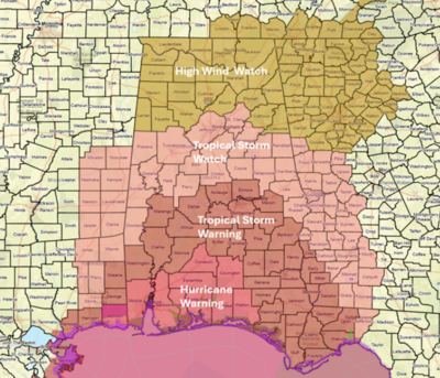
A hurricane warning was in effect Friday morning for Mobile, Baldwin, Conecuh, Covington and Escambia counties. Tropical storm warnings and watches were in effect for central and southern Alabama.
Gov. Kay Ivey Wednesday declared a state of emergency in 40 counties in central and southern Alabama and on Thursday ordered mandatory evacuations of visitors in coastal Alabama. Alabama Attorney General Steve Marshall said in a statement Friday the declaration put the state’s price-gouging laws into effect. The law could subject people who raise prices of a good or service 25% or more over the average cost over the previous 30 days to fines of up to $1,000, unless the increase is due to a reasonable cost.
Places in south Alabama such as Evergreen and Greenville could experience up to six inches of rain. As it travels further north, places in northern Alabama could have between two to three inches of rain.
Winds are expected to exceed 70 mph in Mobile and Baldwin counties.
According to the Alabama Emergency Management Agency, storm surges are expected to reach between six and nine feet along the coastal areas and four to six feet in Mobile Bay.
“People need to begin making preparations,” Holmes said.
- 10:50 amUpdated at 10:50 a.m. with comments from Attorney General's Office on price gouging.
Montgomery