Tennessee prepares for heavy rain, strong winds brought by Hurricane Isaias
Oct 08, 2026 | 6:25 pm ET
Description
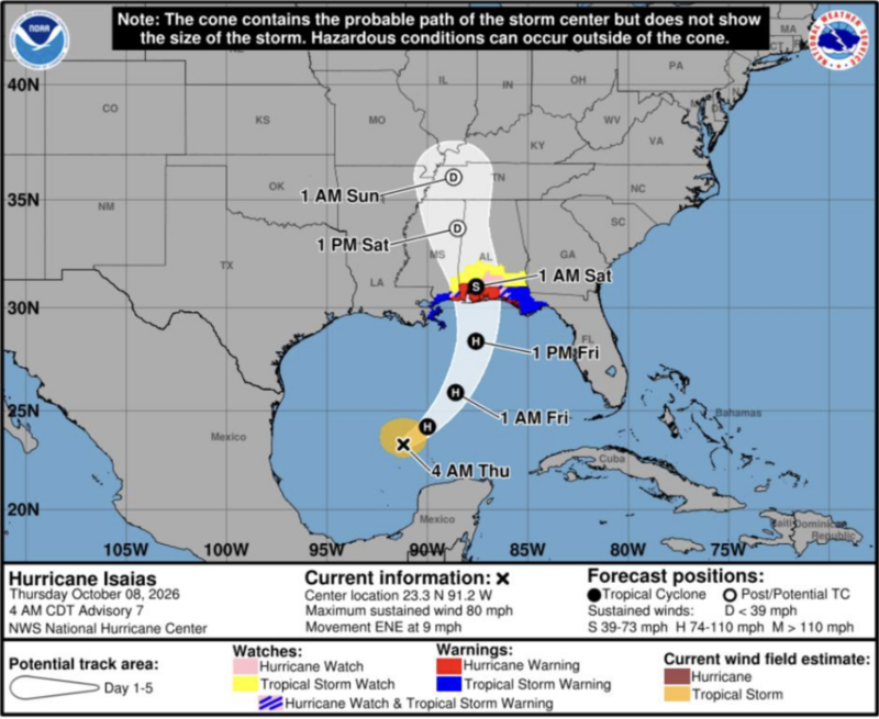
The remnants of Hurricane Isaias is expected to bring periods of heavy rain and wind gusts to Tennessee between Oct. 9 and Oct. 11, 2026. (Courtesy of the National Weather Service)
Hurricane Isaias is expected to bring periods of heavy rain and wind gusts to Tennessee this weekend, according to the National Weather Service.
The hurricane is expected to intensify as it nears the Gulf Coast and make landfall Friday night, then move through the Tennessee River Valley over the weekend. While the storm is projected to weaken before it crosses into Tennessee, the National Weather Service has issued flood watches for most of West Tennessee and Middle Tennessee, in addition to counties along the state’s southern border in East Tennessee from Friday evening through Sunday morning.
A high wind watch is also in place along Tennessee’s eastern border from Saturday morning to Sunday morning.
West Tennessee
Total rainfall is expected to be between one to three inches, though areas near the Tennessee River could see local amounts up to four inches, the National Weather Service reported Thursday.
Rain greater than two inches is most likely along Tennessee’s southern border above Mississippi and Alabama. Memphis has a 49% chance of seeing more than two inches of rain.
Counties under flood watch include Benton, Carroll, Chester, Crockett, Decatur, Dyer, Fayette, Gibson, Hardeman, Hardin, Haywood, Henderson, Lauderdale, Madison, McNairy, Shelby and Tipton.
Wind gusts could reach 35 miles per hour.
Middle Tennessee
Middle Tennessee is expected to see between one and three inches of rain, mostly on Saturday through Saturday night.
Counties under flood watch include Bedford, Cheatham, Coffee, Davidson, Dickson, Giles, Grundy, Hickman, Humphreys, Lawrence, Lewis, Marshall, Maury, Perry, Rutherford, Wayne and Williamson.
Wind gusts could reach 40 miles per hour.
East Tennessee
The remnants of Hurricane Isaias are expected to bring “heavy rain and strong gusty winds” to East Tennessee, with gusts topping 70 miles per hour possible in the region’s mountains and foothills, according to NWS.
Gusts between 30 and 40 miles per hour are likely in the Cumberland Plateau.
One to two inches of rain is expected in the Cumberland Plateau, the southern Tennessee Valley and southwest North Carolina.
Counties under high wind watch from Saturday morning to Sunday morning include Bradley, East Polk, Hamilton, Marion and West Polk.
Counties under flood watch include Bradley, East Polk, Hamilton, Marion, Sequatchie and West Polk.
Nashville, TN